Proposals
Key information about the site
We are bringing forward an outline application for new market and affordable homes in Bicknacre, as well as a community hub alongside green open space and allotments for new and existing residents to enjoy and biodiversity enhancements.

The proposals present an opportunity to help deliver much needed housing whilst also delivering a new community hub to include workspace and a café alongside green open space and allotments for new and existing residents to enjoy.
- A mix of up to 250 new high-quality homes including self-build, accessible and specialist residential accommodation
- 35% of homes to comprise of affordable tenures
- A community hub including workspaces and café with outdoor seating
- A community park with circular walking routes for all to enjoy
- A community allotment for both new and existing residents
- Pedestrian and cycle routes to enhance connectivity and promote active travel
- A biodiversity net gain in excess of 10%

The site
Site location
The proposed site is located to the west of Bicknacre.
The eastern edge of the site is bound by the rear gardens of homes on Barbrook Way, the southern edge of the site is bound by a number of fields and agricultural land, and further to the west of the site, is the village of East Hanningfield.
Due to the flat nature of the land and the landscape features such as mature tree lines and hedgerows which help to enclose it, the site is not widely visible beyond its immediate context. Additionally, there are areas on site which are suitable for landscape enhancements, such as hedgerow improvements and creating green connections across the wider area, as well as further screening the proposed development.
The site benefits from good public transport links including a school bus stop along Priory Road as well as being within a 10-minute walking distance from Greenwood and Wyncroft Surgery, Bicknacre Post Office, Priory Village Store, Bicknacre St Andrew’s Church, the Drunken Dragon Pub as well as further bus stops, making the site sustainably located to the existing amenities in the village.
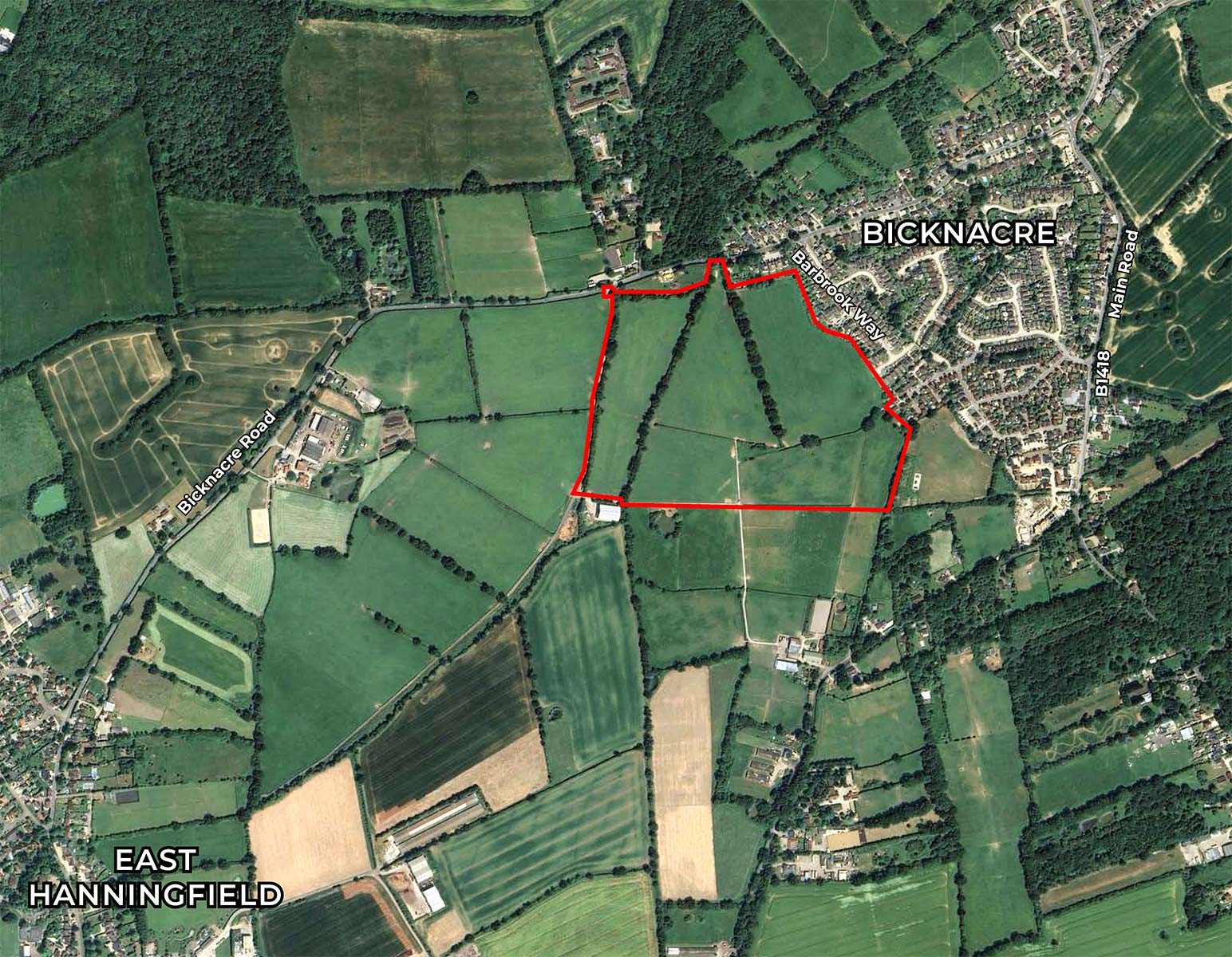
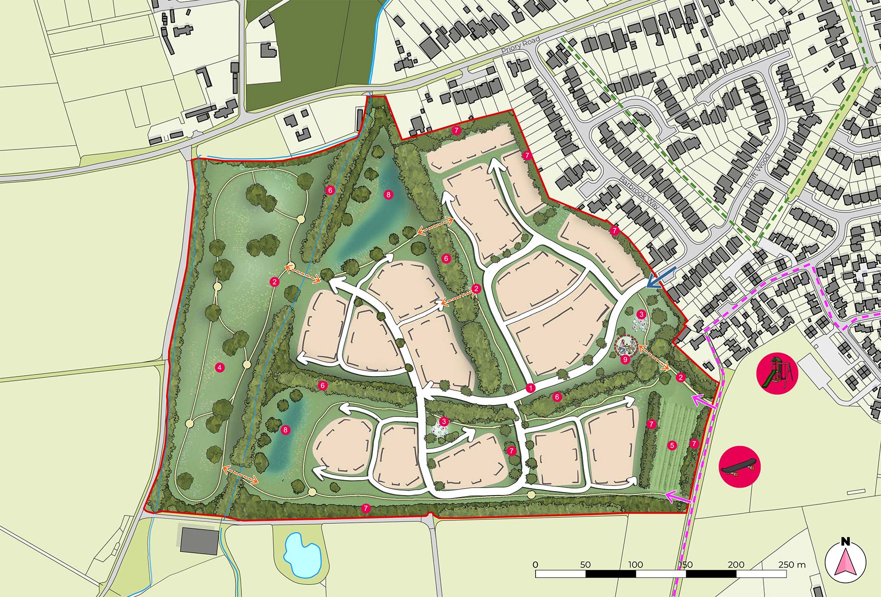
 Site boundary (17.88ha)
 Existing Bridleway
 Existing footpath
 Potential development parcel
 Indicative building frontage
 Indicative vehicular movement
 Indicative recreational routes
 Proposed play space
 Strategic open green space
 Potential area for community allotments
 Existing vegetation
 Proposed vegetation
 Area reserved for attenuation
 Potential area for community uses
 Existing play
 Existing Skatepark
 Existing ditch
 Proposed vehicular access
 Proposed pedestrian access from PRoW
 Proposed pedestrain cut throughs
New homes
High-quality housing that meets local needs
The proposals will deliver up to 250 high-quality new homes, in a range of housing types sizes and tenures addressing the differing needs of residents in Bicknacre helping address the housing shortfall.
Given that this is an outline application and is to establish the principle of the new homes, the detailed design will come forward at a later Reserved Matters stage. The new homes will be designed to not only complement the local area but also to allow the development to establish its own distinct sense of place, helping create a community.
As part of the proposals, 35% affordable housing will be provided in varying sizes and tenures including affordable rent and shared ownership, offering a range of options for residents looking to get onto the housing ladder.
Additionally, the new homes proposed include self-build homes and homes accessible for those with specialist needs.

New community hub
What would you like to see from a new community hub?
As part of the proposals, Welbeck Land is proposing to also deliver a community hub as part of the development.
The proposed community hub could feature work spaces and a café with outdoor seating, however, we would like to hear from the local community on what they would like to see delivered.
The proposed community hub is located on the eastern edge of the site close to the access to the development off Barbrook Way creating a gateway to the development. This location is proposed so that the hub can be used by both new and existing residents and is well located for pedestrians and cyclists.

Active travel
Fostering active living in Bicknacre
Our development is designed with health and well-being at its core, providing numerous opportunities for residents to lead active and healthy lives.
The proposals incorporate cycling and walking routes to help promote cycling and walking as primary modes of transport, enhancing connectivity and reducing the reliance on cars for those living within the development.
The street and pathway network is designed to be easily accessible, encouraging active travel such as walking and cycling. The focus is on making the experience pleasant and safe, with active, well-lit spaces. Importantly, it will be inclusive, providing dedicated, safe routes for pedestrians and cyclists alongside roads, ensuring that everyone, including those with disabilities, can move around comfortably.
These footpath provisions include ‘edible’ and ‘trim’ trails along the recreational routes for all to enjoy.

Commitment to sustainability
Sustainability is at the heart of our development strategy to support a sustainable future
The proposals have been developed with sustainability as a core principle, recognising Chelmsford City Council’s carbon management Climate emergency declaration and action plan.
All buildings will be designed to be fully compliant with the Building Regulation requirements, with high sustainability standards of energy efficiency. They will be thermally efficient with high insulation to reduce reliance on main heating systems.
Additionally, Electric Vehicle (EV) Charging Infrastructure will be provided for all new homes, which will contribute to the scheme’s overall sustainability. Also, there will be provision for cycle storage for all properties to encourage the use of alternative modes of transport to the car.

Site access
Carefully designed access arrangements
Our proposed vehicular access point for the new development will be through the creation of a new access off Barbrook Way to the east of the development.
In addition to the vehicular access point, there will also be several pedestrian and cycle access points connecting with the existing Public Right of Way on the eastern boundary.

Planning context
Allocation in the local plan
Part of the site has been allocated within Chelmsford City Council’s emerging draft Local Plan under Growth Site Policy 11c. The whole site was assessed to be suitable for development within Chelmsford City Council’s Strategic Housing and Employment Land Availability Assessment (under site reference CFS158) and covers just under 18 hectares as outlined in the red-line image above.